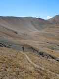
05 Oct Classic Fall Hikes: Telluride's Wasatch Trail
by Erik Dalton
 Bear Creek is well known to most Telluriders. The popular hike to the falls has always been a great escape from town. Big trees, gushing creeks, and expansive views welcome hikers as they enter the canyon from the edge of town. The Wasatch Trail is essentially a continuation of the Bear Creek Trail, taking the hiker high above the falls, eventually cresting the high ridges surrounding the basin at 13,000 ft. Although the Wasatch Trail is not for the faint of heart, it is certainly a trail worth every bit of effort, especially in the fall when you can almost be assured it will be just you and the marmots up in the high country.
The Wasatch Trail is marked by a small wooden sign located in the last big flat area before you reach Bear Creek Falls. As soon as you turn right onto the Wasatch Trail, you immediately start climbing towards the cliff bands above, traversing numerous switchbacks as you work yourself high on the hillside towering over the falls.
After about 30 minutes, the trail traverses the hillside and parallels Bear Creek as it works its way up the basin, across an old bridge, and into a hanging valley that looks down on lower Bear Creek. This first high spot is a great place for a break, which you would be well advised to take considering the climbing to come.
 The Wasatch Trail tops out at 13,000 ft. at a high alpine saddle that separates the Bear Creek drainage from the Bridal Veil drainage. It is approximately 4.8 miles and 4300 feet of elevation gain from town to reach this saddle, no easy feat but completely worth the effort.
From the first hanging valley above the Bear Creek Falls, it is approximately 2 ½ hours up to the saddle, most of which is spent climbing up the switchbacks and scree fields that parallel the tributaries of Bear Creek in the upper basin. There is a split halfway up the Wasatch, where one trail runs up the east side of the creek while the other runs up the west. Eventually they reconnect before reaching the summit. You can choose either direction to hike, though bearing left on the East Fork trail requires a bit more climbing. Once the trails reconnect, its approximately an hour hike to the summit, well above tree line, winding your way through large rocks, following the small rock cairns built to designate the route.
Once on top of Bear Creek, the views back into the basin below are expansive, as are the views into Bridal Veil Basin. Although the Wasatch Trail can be hiked as an out and back by retracing your ascent route, it is most fun to make a loop of it and hike out towards the power station on Bridal Veil Falls.
From the summit, bear left on Blixt Road, marked by a metal sign at the summit. You will come to a junction after 15 minutes of hiking, where you make a right to follow the old mining road down into Bridal Veil Basin. From here, the old road leads you right to the power plant, passing many other popular trailheads along the way such as Blue Lake and Silver Lake. The Bridal Veil Power Station is a great place to drop off a car at the start of your hike so you have a ride down the dusty jeep road back to town. After almost 8 miles of hiking, getting off your feet might be a welcomed relief.
The Wasatch Trail loop can be done in approximately 8 hours, but be sure to bring plenty of food and water to keep yourself energized along the way.
(photos by Erik Dalton)


Sorry, the comment form is closed at this time.